


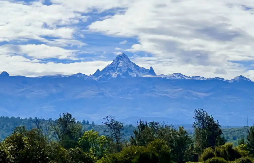
Ngare Ndare. The name twists your tongue long before the hiking trail twists your ankles, and somewhere between phonetics and misadventure, you get one of Kenya’s better day hikes. Set at the foot of Mount Kenya, Ngare Ndare is part hiking trail, part obstacle course if you dare attempt it during the rainy season. Which, of course, we did.
Getting There Is Half the Adventure
Let’s begin with the simple fact that besides being a UNESCO World Heritage Site, Ngare Ndare is remote. And not just “off the beaten path” remote. I’m talking “even Google Maps throws in the towel” remote. If you’re coming from Nanyuki, the easiest way is to branch off near Timau. That is, of course, assuming you can find the turnoff. Spoiler alert: we didn’t.
Instead, we took a more “scenic” route past the Timau Polo Club (yes, apparently there is one), blissfully unaware that most people in their right mind avoid that road when it has just rained heavily. You can probably guess how that turned out..
Cue the drama. A couple of self-proclaimed know-it-all locals with colonial accents scoffed at the advice of the friendly farmers trying to help us, before taking off. Thankfully, those local farmers, with first-hand experience of the road and situation, plus some younger lads who were ready to help us push, eventually got our now-muddy car back on to a drivable section of the road. Conclusion? When hiking in Ngare Ndare, especially during the rainy season, listen to the guys in gumboots, not the ones in khakis.
Welcome to the Ngare Ndare Forest – Sort Of
Eventually, and I do mean eventually, we rolled up to the Ngare Ndare Forest Gate, rattled but intact. Now here’s something worth knowing: you need to book a guide in advance. There’s a website for that. Or rather, there’s a form on the website that looks functional. It was not.
To be on the safe side, I had sent them a WhatsApp message, which they only opened when I stood at the gate and asked whether they had received it.
In the end, the head ranger assigned us a guide at the gate. Thankfully. This is not the kind of terrain you tackle solo. Especially not in the rainy season. Our guide was cheerful, full of insight, and clearly found our muddy misadventures rather entertaining.
The Ngare Ndare hike itself is about 7 kilometres each way, winding through dense forest, towering trees, dappled sunlight, and the kind of stillness you usually only get far from major roads and settlements. The pace changes under those trees. Big trunks, heavy shade, and hikers like us trying not to stumble over the roots.
The trail was still a bit muddy from the previous night’s downpour, but nothing a good pair of hiking boots couldn’t handle. A few slips and slides along the way, but nothing serious.
The trail was far from crowded. We met maybe four or five other groups who were already on their way back, and by the time we got to the waterfalls, we were the last hikers left in the forest. That’s right: Ngare Ndare waterfall to ourselves, and noone else in sight. Bliss.
Mud, River Crossings, and a Triple Waterfall
After meandering through the forest, we came to a fairly steep descent leading down toward the river. The path narrowed, the mud thickened, and the real fun began. This final stretch follows the river downstream from the waterfall and involves a couple of crossings. Nothing too Indiana Jones, but it had its moments.
We crossed on slippery stones, balancing as if staying dry actually mattered, which it did. We got through that final section with our dignity just about intact.
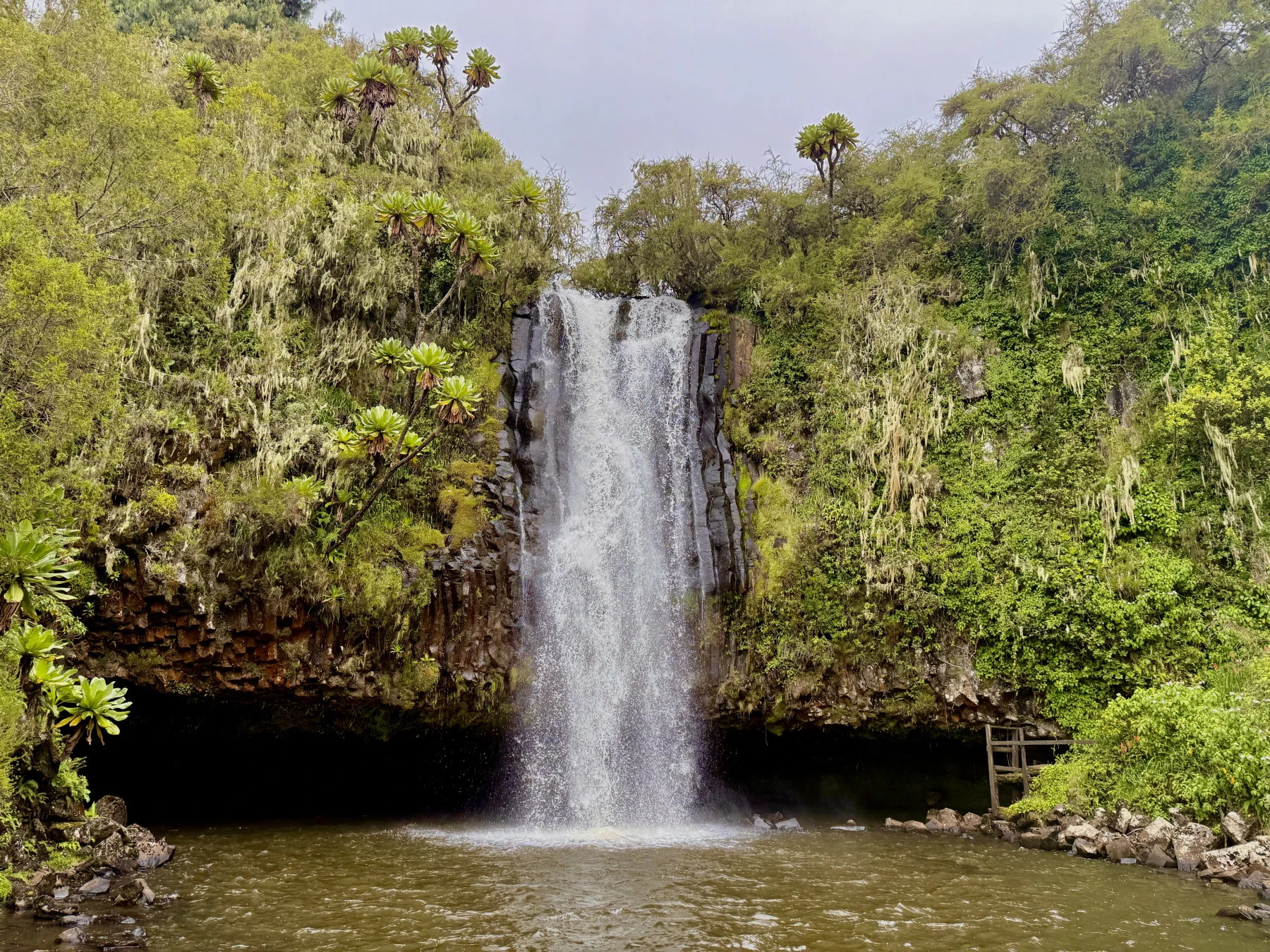
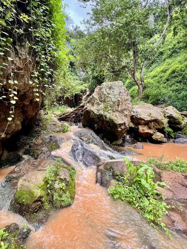
Then there it was. The Ngare Ndare waterfall. Actually, three of them. A triple cascade pouring out of a towering green wall of vegetation. The sort of scene that came dangerously close to needing a soundtrack.
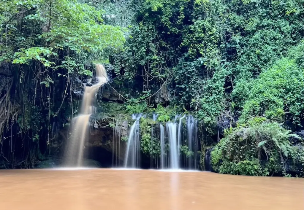
Sadly, the rain from the night before had turned one of the river tributaries into a cappuccino stream, so the famous crystal-clear turquoise pool beneath the falls looked more like a giant mug of chai latte. Still beautiful, but not the classic postcard version.
Swimming is usually one of the highlights here – just not for us that day. I stood there, swimming shorts in hand, seriously considering a dip. But one look at the murky mystery swirling below the surface made me pause. I do prefer seeing what’s under my feet before stepping in – especially when walking barefoot. With another 7 km of hiking still ahead, the idea of wading into a chai-latte-colored pool lost its charm pretty quickly. I do value the well-being of my feet.
“Daddy, Are We There Yet?”
On the way back, the inevitable questions arose. “Daddy, how much longer?” and “Are we almost there?” came up with increasing frequency. But to their credit, the girls powered through – shoulder-carry-free, I might add.
We reached the trailhead to the sound of two elated girls cheering the end of the hike. But Ngare Ndare had more to offer.
The Canopy Walk – Africa’s longest
Just when you’re about to congratulate yourself with a a hike well done, you remember there’s a canopy walk suspended high above the treetops. And not just any canopy walk – this one stretches a whopping 450 meters, officially the longest of its kind in Africa, comfortably outpacing the 401-meter version at Lekki Conservation Centre in Nigeria.
Lekki’s legacy branding still claims “Africa’s longest,” though – so mention this at your own risk around Nigerians.
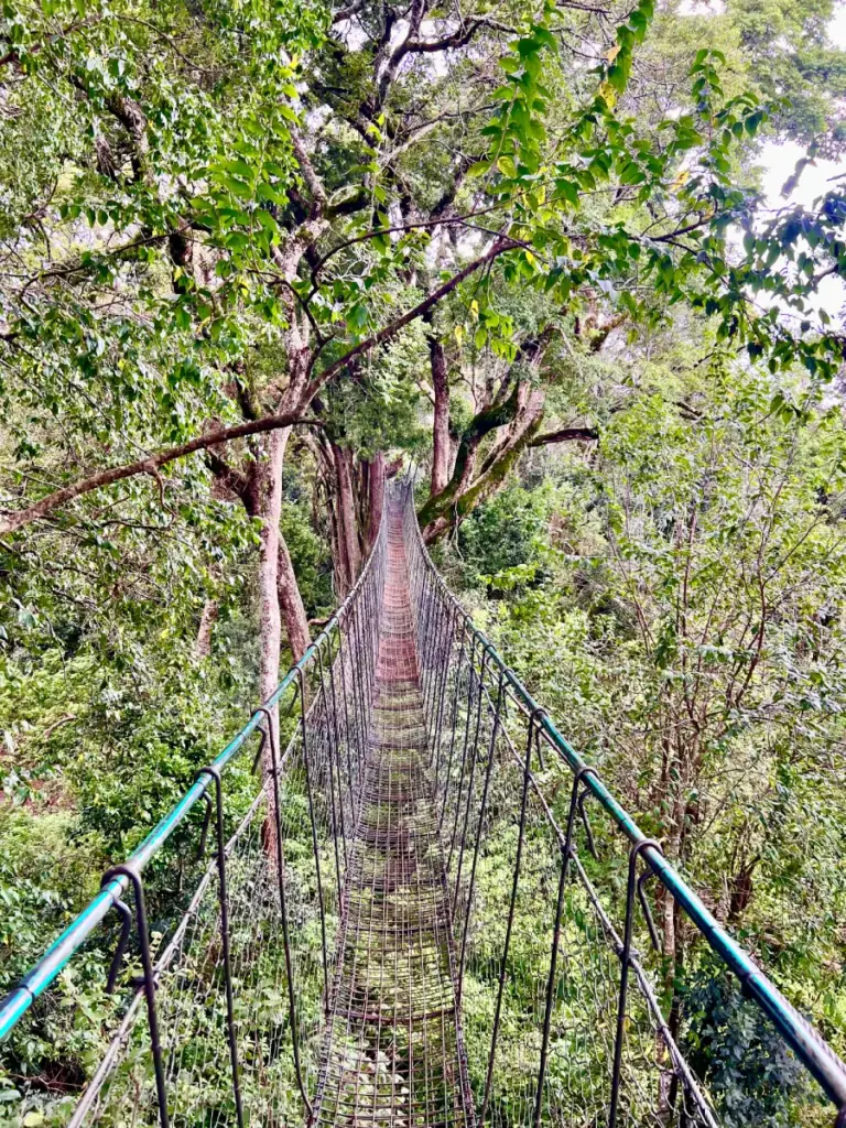
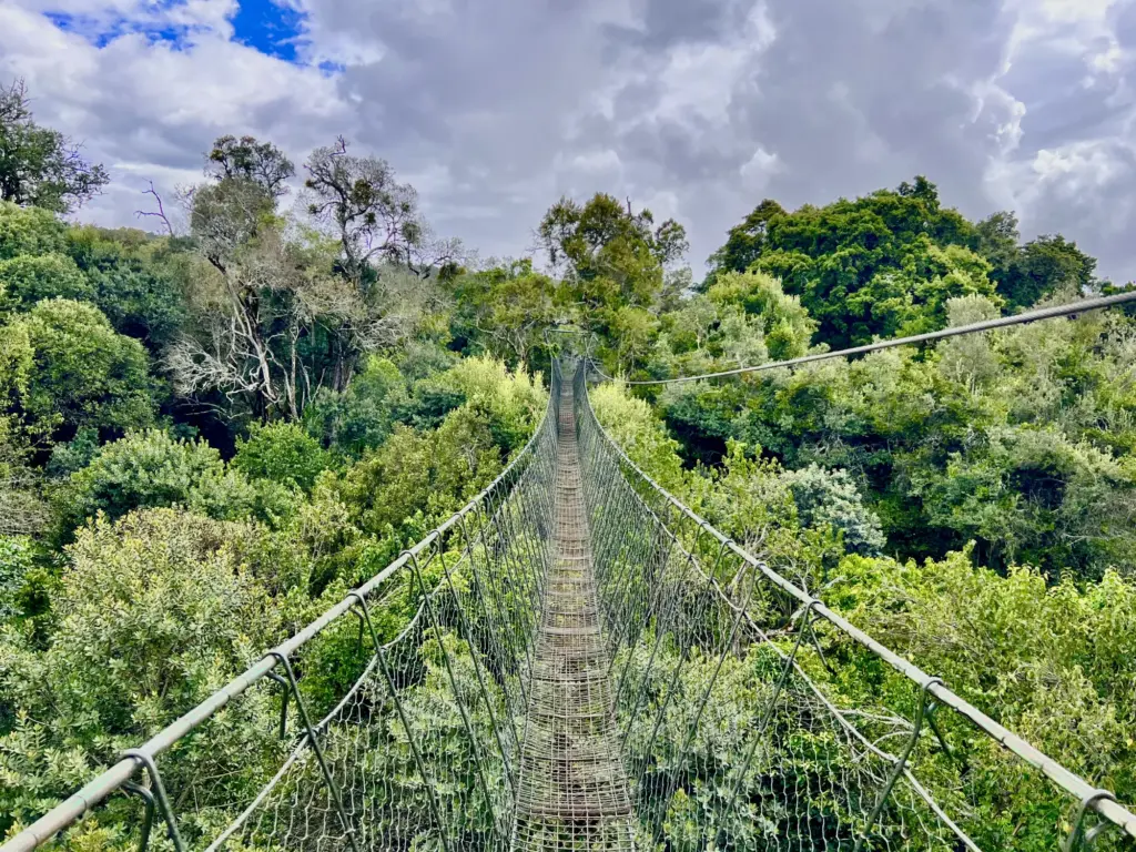
The canopy bridge runs high above the forest and gives you a clear view across the treetops. Most of the time you’re above the canopy. In a few sections, almost inside it. The views are excellent, and so is the drop. The bridge itself feels solid, with thick steel cables and no obvious reason to panic.
I’m not afraid of heights, but my youngest, Ylva, wasn’t too pleased once her older sister Sunniva started testing the bounce factor. That brought immediate protests and some “never forgive you” glares. I, on the other hand, found myself pondering what soundtrack this crossing deserved.
The Trout Tree and Boba Tea Showdown
We wrapped up our forest adventure in Ngare Ndare as the sky kept shifting towards an ever-darker shade of grey. It was time to get moving before the road turned ugly again. Happy and hungry, we hit the road.
My perfect ending of a day like that would have been at the Trout Tree Restaurant in Naro Moru, indulging in fresh river trout, overlooking a river from a mighty mugumo (fig) tree. One of my all-time favourite places in the Mount Kenya region.
The girls had other ideas. Trout Tree was vetoed loudly in favour of Java House at Cedar Mall. Why? Because they have boba tea. At least they had earned it.
Bonus Track: The Mau Mau Cave Hike (Almost)
There is another very decent hike in the same general area: the trail up to the Mau Mau Cave from the Bantu Lodge side near Naro Moru. I did that one back in 2002, in my earlier Kenya days, with three fellow exchange students and a couple of horses.
This time, it was meant to be the warm-up act the day before Ngare Ndare. Then the rain got involved and the plan collapsed with surprising efficiency. Probably the right call. That trail gets slippery fast, and there is a point where persistence stops being admirable and starts being a mildly stupid hobby.
So we dropped it. Mount Kenya was not going anywhere. And, to be fair, Ngare Ndare gave us enough forest, mud, and logistical friction for one weekend anyway.
Getting to Mount Kenya
The road from Nairobi to Nyeri is much improved. A long stretch is now dual carriageway, which means the journey starts off as an unusually smooth ride.
That feeling does not last forever.
After Nyeri, it goes back to the old format. Single carriageway. Overlapping. Random acts of optimism. People treating oncoming traffic as a detail to be negotiated later. The usual.
Still, it is a far easier drive than it used to be, and that makes a difference. If you are heading up for a hike, it is better to arrive with legs intact and blood pressure more or less under control.
More Hikes Around Mount Kenya
This part of Kenya is full of walks, and Ngare Ndare is just one of them. A good one, yes. But not the only reason to head this way.
Point Lenana is high on my list. Sirimon up, Chogoria down. That seems to be the combination people mention with the satisfied tone of those who have suffered a bit and would like company.
The Mau Mau Cave hike also deserves another proper go, ideally without rain shutting the whole plan down before it starts.
Then, there’s the Aberdares just nearby.
So yes, there will be more Mount Kenya hikes. More trails, more altitude, more erratic weather.
And, with any luck, fewer bad road choices.